
Byron Bay Lighthouse Walk: The Cape Byron Track Guide
Published 26 October 2026
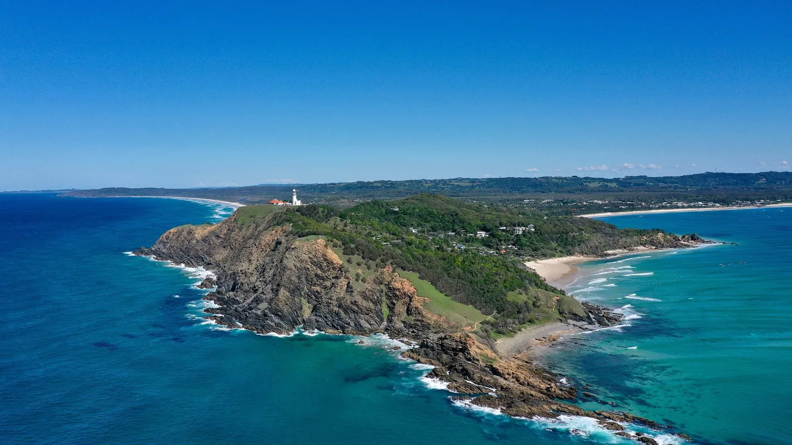
Photo: Kpravin2, CC BY-SA 4.0, via Wikimedia Commons.
The Byron Bay lighthouse walk is one of the best short coastal walks in Australia. NSW National Parks and Wildlife Service (NPWS) calls it "one of the best ways to spend a couple of hours on the state's entire coast". The official name is the Walgun Cape Byron walking track. It's a 3.7 km loop through rainforest, beaches, grassland and clifftops, up to Cape Byron Lighthouse on the most easterly point of the Australian mainland. This guide covers the loop, where to start and park, what it costs to park, when to see whales, and an easier option. All details are from NPWS pages checked on 25 October 2026.
Byron Bay lighthouse walk at a glance
- Track: Walgun Cape Byron walking track
- Distance: 3.7 km loop
- Time: 1–3 hours (NPWS suggests a good two hours to enjoy it properly)
- Grade: 3. Clearly signposted, no experience needed, but short steep hills and many steps
- Path: formed track
- Park: Walgun Cape Byron State Conservation Area
- Pets: not permitted, apart from certified assistance animals
The walk, section by section
NPWS describes the loop passing through the shade of bangalow palms and ancient burrawangs, across kangaroo grasslands, along beaches and up to the lighthouse. Watch the water for turtles, dolphins, stingrays and, in season, whales.
You can start at several points: Captain Cook lookout, The Pass, Wategos Beach or Cape Byron Lighthouse. A classic way to walk it from town is:
- Captain Cook lookout to The Pass. Start near the lookout. NPWS says the boardwalk from Captain Cook Lookout to Brooke Drive is pram and wheelchair accessible.
- The Pass and Palm Valley. The Pass is a famous surf beach. NPWS says it's home to the oldest Aboriginal midden in the region, which NPWS protects with Aboriginal community partners.
- Up to Wategos Beach. Continue along the coast to Wategos Beach, one of the picnic spots NPWS lists in the park.
- The headland and lighthouse. Steps lead up the headland to Cape Byron Lighthouse and its ocean and hinterland views.
- Back via the grassland and rainforest. Complete the loop past kangaroo grassland back toward your start.
Prefer something easier? NPWS notes you can join the track at several points and walk shorter sections. Most of the track is steep with many steps, so it's tougher than the distance suggests.
Cape Byron Lighthouse
NPWS says Cape Byron Lighthouse has stood on "Australia's most easterly point" for over a century. It was built to protect ships passing along the coast and run by resident keepers until 1989. Its light is now automated and clearly visible from Byron Bay. There's no wheelchair access to the lighthouse itself.
- Maritime Museum: in the former Lighthouse Keeper's office at the base of the lighthouse, open 10 am to 4 pm daily.
- Lighthouse lawn: open 8 am to sunset.
- Tours: guided tours of the lighthouse or museum run on limited days and times. Contact the NPWS Byron office on 02 6639 8300 to book.
- Café: NPWS says the Cape Byron Lighthouse Café is closed until further notice from 31 May 2026, so bring water and snacks.
- Stay: you can book heritage keepers' cottages within the park.
See the NPWS Cape Byron Lighthouse page for the latest.
Parking and fees
Parking is available at Captain Cook lookout, The Pass, Wategos Beach and the lighthouse. NPWS warns it can be busy on weekends, so parking may be limited. From Byron Bay town centre, follow Lawson Street (which becomes Lighthouse Road) and look for the signs.
When we checked on 25 October 2026, NPWS listed these park entry fees:
- Cape Byron Lighthouse lawn and Information Centre car park: $10 per vehicle per hour ($4 per hour for motorcycles). There's a maximum of 1 hour per vehicle per calendar day, including for NPWS annual pass holders.
- Bawaii rest area, Cosy Corner and The Pass: $5 per vehicle or motorcycle per hour.
The 1-hour limit at the top is a good reason to start from town or The Pass and walk up, rather than drive to the lighthouse. Check the current fees on the Walgun Cape Byron State Conservation Area page before you go.
Easier option: Palm Valley Currenbah walking track
If you'd rather not tackle the steps, the Palm Valley Currenbah walking track is a 0.7 km Grade 1 loop. It takes about 10 minutes, and it's flat and paved, which suits prams and wheelchairs. It starts at the Palm Valley car park next to The Pass Café and winds through shaded palm rainforest, with picnic and barbecue facilities at either end. NPWS warns to watch for large biting ants on the track.
Best time to walk to Byron Bay lighthouse
- Whale season: NPWS names Fishermans Lookout, near The Pass, as a top spot for migrating whales between June and November. Bring binoculars.
- Spring: NPWS says it's cooler and perfect for walking.
- Summer: averages are 22–27°C. Start early to beat the heat and the crowds.
- Winter: averages are 15–21°C, with good whale watching.
- Rain: March is the wettest month and September the driest.
Sunrise is a popular time. NPWS lists a licensed guided sunrise tour, and a guided Aboriginal cultural tour of the headland is also available.
Safety tips
- Stick to the track and stay away from cliff edges, as NPWS advises.
- Beaches aren't patrolled in the park and can have strong rip currents. Swim at a patrolled beach between the red and yellow flags.
- Mobile reception is limited in places. Download the Emergency Plus app and dial Triple Zero (000) in an emergency.
- No drones: recreational drone flying is prohibited.
- Bring water, a hat and sunscreen, as there's little shade on the clifftops.
Read the NPWS Walgun Cape Byron walking track page for the factsheet and map.
More coastal walks for Queenslanders
Love headland walks? South-east Queensland has plenty. Browse all Active Quests trails for coastal tracks, or read our Mount Coot-tha Summit Track guide for a city training walk. You can learn how GPS check-in quests work on the Active Quests home page.
Related guides
- Border Ranges National Park: Best Walks & Pinnacle Lookout
- Dorrigo National Park: Best Walks, Skywalk & Waterfalls
- Minyon Falls Walk: Track Guide, Lookout & Tips
- Gold Coast Waterfall Walks
New NSW quests nearby
Frequently asked questions
How long is the Byron Bay lighthouse walk?
The Walgun Cape Byron walking track is a 3.7 km loop. NPWS suggests 1–3 hours, and a good two hours to enjoy it properly.
Is the Cape Byron walking track hard?
It's Grade 3. No experience is needed and it's clearly signposted, but there are short steep hills and many steps.
Where do you start the Byron Bay lighthouse walk?
You can start at Captain Cook lookout, The Pass, Wategos Beach or Cape Byron Lighthouse. Starting from town or The Pass avoids the 1-hour parking limit at the lighthouse.
Do you have to pay to park at Byron Bay lighthouse?
Yes. On 25 October 2026, NPWS listed $10 per vehicle per hour at the lighthouse car park, with a maximum of 1 hour per day. Check NPWS for current fees.
Can you go inside Cape Byron Lighthouse?
Guided tours of the lighthouse and Maritime Museum run on limited days and times. Contact the NPWS Byron office to book. The museum is open 10 am to 4 pm daily.
When can you see whales from Cape Byron?
NPWS says migrating whales can be seen from Fishermans Lookout between June and November. Winter is a highlight.
Tours & experiences near Byron Bay & Northern Rivers
Turn your walk into a quest
Active Quests turns real-world walks into GPS check-in quests where you earn ACTIVE Coins. Find your next trail on the App Store.